
Bunyi mesin ces memecah keheningan pagi, melaju menyusuri kanal dan handel mengantar tim hidrologi bersiap menuju titik pemantauan di kawasan hutan desa Kahayan Hilir, Kalimantan Tengah. Kegiatan pemantauan dilakukan oleh tim hidrologi KPSHK dan anggota Lembaga Pengelola Hutan Desa (LPHD). Meteran I, Shuttle HOBO perangkat portabel untuk membaca, menyimpan, dan memindahkan data, seperti data pencatat suhu atau ketinggian air menjadi perangkat standar yang mereka gunakan.
Pengambilan data berlangsung selama tujuh hari, mulai 23 April hingga 1 Mei 2026. Pemantauan ini dilakukan untuk memastikan kondisi gambut tetap basah dan tidak mudah terbakar saat musim kemarau. Dalam kawasan gambut, air menjadi penentu penting. Gambut yang tetap basah lebih mampu menahan api, sedangkan gambut yang mengering lebih mudah terbakar.
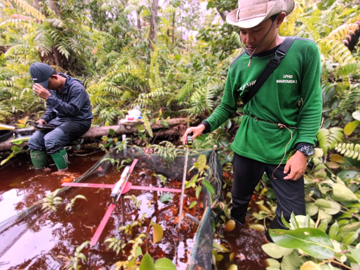
Pengambilan data TMAT di Hutan Desa Mantaren I. Sumber foto: KPSHK.
Pemantauan tinggi muka air tanah atau TMAT dilakukan dengan dua cara; secara manual menggunakan meteran dan secara otomatis menggunakan sensor HOBO. HOBO merupakan alat pemantau yang dipasang di sumur pantau gambut untuk merekam perubahan tinggi muka air secara berkala. “Data ini membantu kami melihat kondisi gambut setelah berbagai intervensi dilakukan,” ujar Salmansyah, Asisten Hidrologi KPSHK. Selain mengambil data TMAT, tim juga mengumpulkan data curah hujan, memantau arus handel dan sungai, mengambil data camera trap, serta merekam suara satwa menggunakan voice recorder.
Sebanyak 20 sensor HOBO telah terpasang di empat hutan desa. Delapan unit berada di Hutan Desa Gohong, lima unit di Hutan Desa Kalawa, dua unit di Hutan Desa Mantaren I, dan lima unit di Hutan Desa Buntoi. Satu sensor tambahan dipasang untuk memantau kondisi udara.
Perjalanan menuju titik pemantauan tidak selalu mudah. Titik yang berada di tepi sungai masih dapat dijangkau menggunakan ces dengan jarak sekitar 50 meter hingga 300 meter dari bibir sungai atau kanal. Namun, beberapa titik lain berada jauh di tengah kawasan hutan desa. Setelah menyusuri kanal atau handel, tim harus melanjutkan perjalanan dengan berjalan kaki. Mereka harus berjalan sejauh lima kilometer untuk mencapai titik pemantauan.
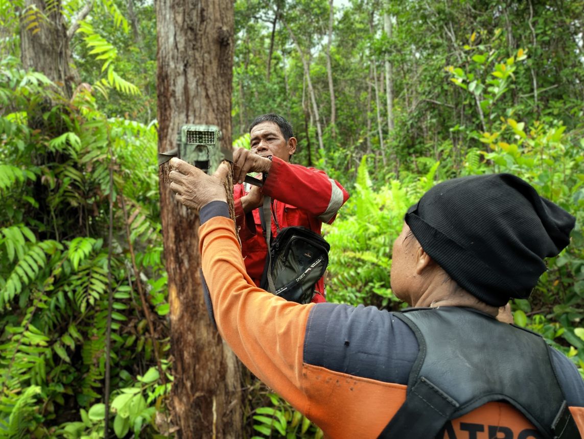
Pengambilan data camera trap di Hutan Desa Mantaren I. Sumber foto: KPSHK.
Pada beberapa lokasi pemantauan, tim harus menempuh perjalanan lebih jauh, bahkan menginap di dalam hutan. Selain harus berjalan kaki, kadang mereka juga menghadapi kondisi seperti saat air handel surut atau melewati jalur yang sempit. Pada kondisi ini, ces tidak dapat melaju. Terpaksa tim harus turun dan mendorong ces agar bisa lolos. “Kalau air surut, perjalanan menuju titik pemantauan bisa lebih lama. Tim harus menyesuaikan dengan kondisi alam,” kata Ari Jatmiko, Asisten Hidrologi KPSHK.
Target pengambilan data berada di lima belas titik pemantauan. Hingga awal Mei, data berhasil diambil di sepuluh titik. Lima titik lain belum bisa dijangkau karena kondisi jalur air dan waktu tempuh. Hasil pengukuran menunjukkan kondisi tinggi muka air tanah relatif aman, masih berada di bawah batas empat puluh sentimeter. “Masih di bawah ambang empat puluh sentimeter, jadi kondisi relatif aman,” ujar Ari Jatmiko.
TMAT di Hutan Desa Gohong berkisar antara 0,7 cm hingga 28,4 cm di atas permukaan tanah (kondisi terendam). TMAT di Hutan Desa Kalawa berada pada kisaran 0,5 cm hingga 22,9 cm di bawah permukaan tanah. TMAT di Hutan Desa Mantaren I tercatat sebesar 19,8 cm di atas permukaan tanah (kondisi terendam). Seluruh hasil pengukuran kemudian dikirim ke sistem monitoring rawa gambut untuk membantu analisis kondisi hidrologi di kawasan Kahayan Hilir.
Pemantauan gambut bukan sekadar mencatat angka. Setiap perjalanan lapangan membantu tim membaca kondisi air, jalur handel, perubahan bentang gambut, serta tantangan menjaga ekosistem gambut tetap basah dan terlindungi dari ancaman kebakaran.
Penulis: Alma
Editor: JW & Kiss
The sound of a ces engine broke the morning silence, cruising along the canal, and the handles carried the hydrology team to the monitoring point in the forest area of Kahayan Hilir Village, Central Kalimantan. The monitoring activities were carried out by the KPSHK hydrology team and members of the Village Forest Management Institution (LPHD). Meter I, Shuttle HOBO, a portable device for reading, storing, and transferring data, such as temperature and water level recordings, were the standard equipment they used.
Data collection took place over seven days, from April 23 to May 1, 2026. This monitoring was conducted to ensure the peat remained moist and flammable during the dry season. In peat areas, water is a crucial factor. Wet peat is more resistant to fire, while dried peat is more flammable.
TMAT data collection in Mantaren I Village Forest. Photo source: KPSHK.
Groundwater level monitoring (TMAT) is carried out in two ways: manually using a meter and automatically using a HOBO sensor. The HOBO is a monitoring device installed in peat monitoring wells to periodically record changes in water level. “This data helps us assess the condition of the peat after various interventions have been implemented,” said Salmansyah, KPSHK Hydrology Assistant. In addition to collecting TMAT data, the team also collected rainfall data, monitored river and stream currents, collected camera trap data, and recorded animal sounds using voice recorders.
A total of 20 HOBO sensors have been installed in four village forests. Eight units are in Gohong Village Forest, five units in Kalawa Village Forest, two units in Mantaren I Village Forest, and five units in Buntoi Village Forest. One additional sensor was installed to monitor air conditions.
Traveling to monitoring points is not always easy. Points on riverbanks can still be reached by ces, with distances of approximately 50 to 300 meters from the riverbank or canal. However, some other points are located deep in the village forest area. After following the canal or ces, the team must continue their journey on foot. They must walk as far as five kilometers to reach the monitoring points.
Camera trap data collection in Mantaren I Village Forest. Photo source: KPSHK.
At some monitoring locations, the team must travel further, even spending the night in the forest. In addition to the trekking, they sometimes encounter conditions such as low tide or narrow paths. In these conditions, ces cannot move. The team was forced to go down and push the cess to get through. “When the water recedes, the journey to the monitoring point can take longer. The team must adapt to the natural conditions,” said Ari Jatmiko, Hydrology Assistant at the Ministry of Environment and Forestry (KPSHK).
The target data collection was fifteen monitoring points. By early May, data had been collected at ten points. Five other points were unreachable due to waterway conditions and travel time. Measurement results indicated that the groundwater level was relatively safe, remaining below the 40-centimeter threshold. “It’s still below the 40-centimeter threshold, so conditions are relatively safe,” said Ari Jatmiko.
The groundwater level (TMAT) in Gohong Village Forest ranged from 0.7 cm to 28.4 cm above ground level (submerged conditions). The TMAT in Kalawa Village Forest ranged from 0.5 cm to 22.9 cm below ground level. The TMAT in Mantaren I Village Forest was recorded at 19.8 cm above ground level (submerged conditions). All measurement results were then sent to the peat swamp monitoring system to assist in the analysis of hydrological conditions in the Kahayan Hilir area.
Peat monitoring isn’t just about recording numbers. Each field trip helps the team understand water conditions, drainage paths, changes in the peat landscape, and the challenges of keeping peat ecosystems moist and protected from fire.
Author: Alma
Editor: JW & Kiss
Add a Comment